Find out how to protect your property during bushfire season, find safe places during a fire and why it’s imperative to have a bushfire survival plan for your family and pets.
Are you Bushfire Ready?
The Fire Danger Season in the Mount Lofty Ranges Fire Ban District begins 15 November 2023 and ends on 30 April 2024.
Bushfire prevention is more than a weekend clean-up before the bushfire season, it’s a year-round responsibility.
If you don’t do your fire hazard reduction work before fire danger season starts, we might issue you with a $315 fine (Section 105F Notice under the Fire and Emergency Services Act 2005). Our contractors will then do the required work at your cost.
To learn how to protect your property from bushfires call 1300 133 466.
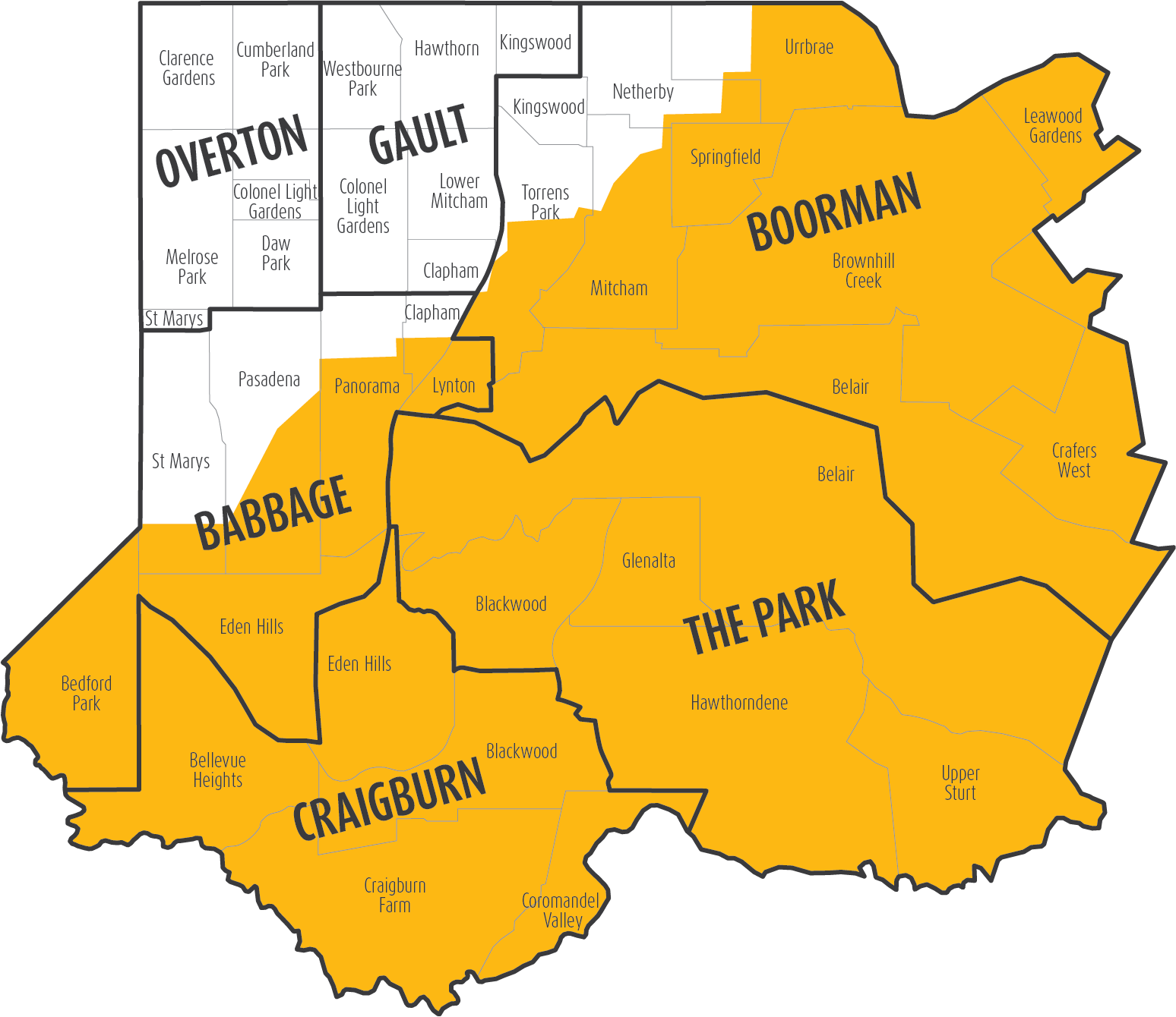
Bushfire areas in the City of Mitcham
West
South Road
North
Ayliffes Road, Fiveash Drive, Goodwood Road, O'Neil Street, Strathcoma Avenue, Barretts Road, Belair Road, Blythewood Road, Old Belair Road, Taylors Road, Fullarton Road, Delamere Avenue, Waite Road, Cross Road.
East
South Eastern Freeway, Council's eastern boundary.
South
Sturt River
Download Living in a High Fire Prone Area
Bushfire safer places
If you live, work or travel in an area where bushfires can happen, and your bushfire survival plan is to leave early (on or before a bad fire day), you need to find a place to move to.
The CFS has two categories of places that offer safety from bushfires: bushfire safer places and last resort refuges. It’s important you know what these are, where they are, and what risk you take if you use one of these options during a bushfire.
Why you need a bushfire survival plan
Thinking ‘I’ll leave early’ is not enough. You must prepare to act and survive.
- Most people who die during bushfires in our state are caught when they flee their homes at the last minute. Preparing your plan helps you to understand the signs to leave early or prepare to actively defend your property.
- Bushfires can be scary and overwhelming. This isn’t the time to make major decisions. Preparing your plan helps you make decisions in advance, and will keep you focused to make better decisions if there's a bushfire threat.
- During a bushfire, you’ll be worried about your loved ones. Preparing and practising your bushfire survival plan helps family members learn where others are and what they’ll be doing.
- You might find you don’t have the clothing, equipment or resources to carry out your plan to leave early or stay and defend at the last minute. A prepared and practised bushfire survival plan helps identify what you need.
- Bushfires are unpredictable and even the best plans can go wrong. Include contingencies and back-ups in case your primary plan fails. Write down and practise your plan for the best chance to survive a bushfire.
Investigating community centres as refuges
Council received information on ways community centres could be made available as a place of refuge on extreme and catastrophic fire danger days to allow residents to seek refuge with their family and domestic pets.
Read item 14.2 Fire danger days places of refuge 13 December 2022
Our bushfire prevention plan
We have a detailed bushfire prevention plan to protect lives and reduce the impact of bushfires on property and our environment.
We reduce fuel loads throughout the hills before and during the fire danger season by removing vegetation, creating fuel breaks, brush cutting, and burning debris on-site.
We do these works in hills areas covering Lynton, Torrens Park, Mitcham, Brown Hill Creek, Leawood Gardens, Crafers West, Upper Sturt, Belair, Glenalta, Hawthorndene, Coromandel Valley, Craigburn Farm, Blackwood, Bellevue Heights, Eden Hills, Panorama and Pasadena.
We have a number of fire management plans with extensive fuel break and fire track recommendations.
Start preparing your property now!
Prescribed burning is only one fuel load reduction tool. Burning promotes weed growth after a fire, and a lot of fires in one area favour some native species and eliminate others, requiring long periods between fire events.
We carefully plan prescribed burning with our staff, CFS volunteers and equipment. We consider vegetation and weather conditions, and consult with our community and the availability of CFS volunteers and trucks to work out if a burn can be done.
To make sure we have fuel breaks in place for the fire danger season, we control weeds, prune large trees, thin native vegetation and cut brush.
We help residents prepare their property for the bushfire season with free green organics drop-off days at the Lynton Green organics drop-off facility.
We have about 500h of bushland and road reserves in the Mitcham hills, and maintain a fire track network of over 15km long.
We build and maintain fuel breaks and fire tracks on reserves in our hills. A regular maintenance program involves:
- Controlling weeds
- Pruning large trees (remove low hanging foliage);
- Thinning-out native vegetation (with government approval);
- Extensive brush cutting;
- Prescribed burning.
Fuel breaks still use vegetation and large trees to lessen soil erosion and weed invasion, and provide a habitat for native animals.
Sheoak Road fuel break
We’ve developed a strategic fuel break along Sheoak Road with funding from Federal and State Government grants.
The strategic fuel break is a 3.2km section of Sheoak Road, east of Pony Ridge Road, and we established it by thinning vegetation, controlling weeds, controlling burns and brush cutting.
The roadside looks more open with sight lines for motorists. We reduced grassy fuels with brush cutting and will continue to maintain the fuel break with weed control in native vegetation.
We did this work with approvals under the Environment Protection and Biodiversity Conservation Act 1999, and the Sheoak Road Vegetation Management Plan, August 2008 approved under the Native Vegetation Act 1991.
Property access
Clear access lets firetrucks move safely. Make your gateways at least 3m wide and make sure your roadways have a well-compacted surface with slopes under 1m for every 4m, with solid crossings over waterways. Your turn area needs a 25m diameter.
Parking in the hills
Where and how you park your vehicle is even more of an issue during the bushfire season.
If the way you park impacts access to fire tracks, traffic or the most direct route to a fire, you’re putting lives and homes at risk.
When you park your vehicle, make sure there’s at least 3m of road clearance alongside your car to let other cars pass. This is required by law and you may save a life!
Mains-fed electricity can be interrupted because of faults, fire damage, or because supply is off to reduce the risk of fire ignition. After the Ash Wednesday bushfires, legislation was introduced to let SA Power Networks turn off power to reduce the chance of a fire starting.
If you live or work in a bushfire prone area and plan to stay and fight a fire, you need to consider alternative power for pumping water and using fire-fighting equipment.
Managing reserves and verges for the bushfire season
The City of Mitcham, situated within the Adelaide and Mount Lofty Ranges Bushfire Management Area, uses the bushfire management area plan to assess bushfire risks and plan prevention activities. This plan guides our strategies, involving vegetation management and fuel reduction on reserves, road verges and unmade road reserves.
We prioritise areas with high fire risks, balancing scenic and biodiversity values with the safety of our community safety. Annual programs involve cutting verges in high-risk areas before the bushfire season. To manage these risks, we use a range of methods including establishing asset protection zones, bushfire buffer zones, managing invasive weeds and reducing fuel loads. Our annual program includes cutting 148 hectares of open spaces and 560km of roadside verges.
We work closely with environmental groups and government departments to ensure reserves and roadsides are managed in a safe and environmentally sustainable manner. For land managed by other authorities such as national park, please contact the relevant responsible entity.
Here's a quick overview of our preparation for the Fire Danger Season:
- Reserve Slashing Program: Our reserve slashing program is 100% completed. This initiative aims to reduce fire hazards and create safe spaces in case of emergencies.
- Roadside Slashing Program: Our roadside slashing program is also 100% complete. Clearing roadside vegetation is crucial for fire prevention and ensuring safe evacuation routes.
- Verge Local Streets Program: Our verges on local streets slashing program is underway, with 100% completed.
We will undertake re-slashing on selected reserves, roadsides and verges.
Council’s bushfire prevention slashing program focuses on improving safety for road users and protecting property and public infrastructure. The program includes Council reserves and roads, using various methods such as vegetation management and bushfire fuel reduction.
Prioritizing high-risk areas, Council annually manages 140 hectares of open space reserve and 560kms of roadside verges. This approach includes asset protection and bushfire buffer zones, invasive weed control, and fuel load reduction, in preparation for the bushfire season.
Council’s bushfire prevention slashing program is conducted by staff and contractors. The program usually starts in spring, depending on weather conditions and is undertaken based on operational needs and identified priorities. It begins in the dry northern areas which generally dries faster, then to the south, aiming for completion by Christmas, however this may be impacted by weather and vegetation curing rates.
Priority areas, typically along major roads and larger reserves are slashed first. The program aims to balance cutting needs with grass curing so areas are only cut once, reducing costs. We try to hold off as late as possible in the season before slashing, prioritising community safety while effectively managing the bushfire risks.
During spring, residents may notice long grass, which can be concerning. Our plan is to slash all Council-managed roadsides and reserves identified as bushfire management priorities before Christmas and before the driest parts of summer arrive.
Our program commences in September and progresses across the Council area with completion by Christmas based on weather and vegetation curing rates.
We cut and slash over 560kms of verges, laneways and road reserves before the fire season to strategically manage potential fire risks.
Why certain areas? Well, they might serve as a fire ignition spot, provide a strategic control line or high-priority emergency routes.
We refer to the bushfire management area plan to identify high-risk areas and key assets that need protection. This plan directs the development of bushfire management strategies of high-risk areas under Council’s control, guiding the establishment of protection and bushfire buffer zones, ensuring the safety of our community and key assets.
Council slashes approximately 148 hectares of reserves, following the bushfire management area plan. We aim to create protection and buffer zones in identified reserves, to safeguard key assets and communities. These works are undertaken from September when grasses and vegetation dry out. Some areas need multiple cuts, while others require one cut each year.
An asset protection zone is an area around a valuable asset, like a home or business, where vegetation is reduced to minimise bushfire impact. This doesn’t mean removing all vegetation, some trees can remain. These zones act as buffers, reducing heat and ember attack, aiding firefighters’ access, and providing a safer space for property defence and back burning during bushfires.
View the location of our protection and bushfire buffer zones
We cut and slash over 560kms of roadside before the fire season. If your area hasn’t been cut or slashed it’s likely because it’s not on our strategic bushfire management list, it’s scheduled for a cut soon, or our contractors just haven’t reached your area yet.
View the bushfire slashing program map
We encourage all property owners and residents to help maintain verges by removing weeds and keeping the grass trimmed. You can also landscape your verge with lawns, garden beds or mulch. Just fill out a quick ‘Works on a Public Road’ application form. Once approved you will be responsible for maintaining your verge. for more information download a fact sheet.
Our staff and/or contractors will cut long grass they can safely access using tractors, slashers or brush cutters. However, certain spots might be too rough or unsafe to access. While these small patches might seem untidy, they usually do not pose significant fire hazards.
Our roadside slashing program covers 560km of roads, but with a limited budget, we must balance the need for cutting and slashing with grass curing. Our aim is to cut once, saving money for both the Council and the community. We start as late in the season as possible, ensuring road and fire safety. We focus on strategic fuel management, ensuring priority areas are slashed. We aim to complete this work before Christmas. During spring, the risk of long green grass causing a fire hazard is lower.
We conduct regular inspections throughout the area, addressing concerns before a complaint is made. However, if you happen to notice tall grass in a neighbouring property or Council managed reserve that needs our attention, please call us on 1300 133 466.
How to protect your pet in an emergency
- Include pets in your survival plan
- Prepare your pet emergency kit
- Practice your plan
How to prepare your pet emergency kit
The kit should include:
- Registration certificates
- Vaccination certificates
- Transportation equipment (cages/carriers/crates/horse floats etc)
- Cat litter and tray
- Poo bags for dogs
- ID tag (including pets name and your mobile phone number), collars, leads, harnesses, saddles etc
- Food and water bowls, and at least one week’s supply of non-refrigerated food
- Medications and clear instructions for treatment of any medical conditions
- Blankets/bedding/nesting material
- Toys/enrichment devices
- Photograph of your pets (including names) in sealed plastic bags
Contact details for your vet, local animal shelter, local council, and alternative animal accommodation facility